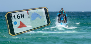
I’ve published my first app on the Google Play Store – a dashboard for personal watercraft, like Jet Skis.
It’s free, all features are enabled, and it has no ads. You can get it here.
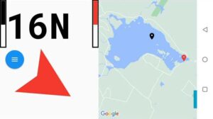
 It shows your speed, in miles per hour if you’re in the US, or kilometers per hour elsewhere; it shows your heading, and it shows the body of water you’re on, with a marker for your current position, and a marker for your launch point. The app stores maps offline, so you don’t need to be in cell range to use this feature.
There’s an arrow that points in the direction of your launch point, to help you find your way back.
Finally, if you’re in New Hampshire, it gives you hints for the spar buoy system in that state.
So, how do you use it? The first time it starts up it will ask for permission to access your location. Of course, it needs that to show your position on the water. All of the information the app collects stays on the phone; none of it sent to any devices on the internet.
The app also uses the GPS to determine your speed and heading. This means that your speed and heading are only as accurate as your GPS is, and how many satellites are providing a fix. The app only uses your phone’s compass when you’re standing still. Phone compasses also rely on the accelerometer to figure out what orientation you’re holding the phone in. But if you’re moving in a boat, bouncing over the waves, the accelerometer becomes useless, and that’s why the app needs to use the GPS to determine your heading.
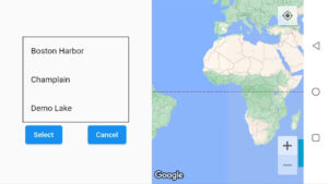
While you’re in cell phone or WiFi range, bring up the menu by tapping the blue circle and tap Select Map. Google Maps appears on the right. You can tap the “Show Your Location” button in the top right and then drag, pinch, and zoom so that your body of water fills the right side. Tap select and give this map a name. The map is stored on the phone. You can store multiple maps, and then select one, without being in cell phone range.
Next, right before you launch your boat, bring up the menu and tap Mark Origin. That remembers your launch point.
Now, you can go out on the water. The app will show your speed, heading, and the arrow will point back to where you launched from. If it’s pointing up, your launch point is straight ahead; if it’s pointing down, your launch point is behind you; if it’s pointing to the side, you need to turn in that direction.
Note that the arrow is pointing in the direction “as the crow flies”. If there’s a body of land between you and your launch point, it does not help you navigate around it.
If you’re in New Hampshire, you’ll see hints for navigating around the state’s spar buoys. You’re supposed to stay south or west of white buoys with red tops, and north or east of white buoys with black tops.
So these hints take your current heading into account and tell you how to navigate around the buoys. In the screen shot, above, it shows that if you see a red-topped buoy, you should keep it to your right. If you see a black topped buoy, you should keep it on your left.
It’s possible for the app to show you two buoys of the same color. For example, if it shows two red topped buoys, it means that if you see a red topped buoy ahead of you on the water, you’re heading directly into a hazardous area.
If the app shows you two red topped buoys, and you see a black topped buoy ahead of you in the water, that’s bad. It means you are currently in a hazardous area!
 Once you have maps saved in the app, when you go to Select Map, you’ll see a list of their names. You can either use the right hand side to find a new body of water, as I showed you before, or just select one of the map names from the list.
Finally, you can delete a stored map by opening the menu and tapping Delete Map. Then tap the name of the map you want to delete.
To use this app on your personal water craft, I recommend you get a cheap, water resistant Android phone. I found one for less that $150 on Amazon. I made a mount out of PVC pipe and I strap it to the steering pole of my stand-up water craft. It’s kludgy, but it works.
So give PWC Dashboard a try. I hope you’ll find it useful.
Here’s a video demo:
